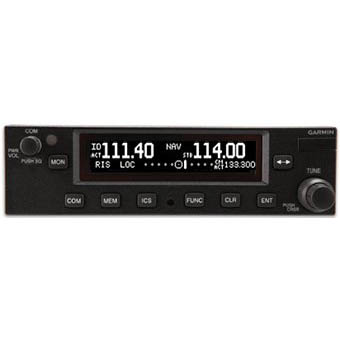
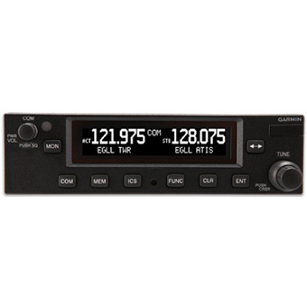
test

Garmin GTN750

Tap into the Future of Avionics

  • Touchscreen GPS/Nav/Comm/MFD backed by decades of proven technology
  • Fly WAAS/SBAS LPV approaches down to 200 foot minimums while displaying charts, traffic, weather and more
  • Approved for installation in hundreds of makes and models of aircraft around the world
  • Interfaces with popular avionics using industry standard protocols
  • Cockpit connectivity via Connext® keeps your tablets and Garmin portables in sync as well as connected with those on the ground
test

Garmin GTX327

Enjoy Innovative Features

GTX 327 features a solid state design, and with no warm up time, lower power consumption and much lower heat emissions, you’ll enjoy a longer service life. It provides 200 watts nominal power output and has an easy-to-read DSTN liquid crystal display which reverses the numbers out of black for optimal viewing. An innovative keypad makes entering a squawk code a snap, and a dedicated VFR button allows for quick-and-easy VFR squawking. Similar to the GTX 330 Mode S transponder, the 327 also offers several timing and display functions, including flight time, count-up and count-down timers, as well as current pressure altitude.

test

Garmin GTX330

Surveillance for Busy Airspace

  • IFR-certified 250 W transponder
  • Optional 1090 MHz ES broadcast technology
  • Easy-to-read LCD display
  • Traffic Information System (TIS-A) alerts on compatible displays
  • Pressure altitude, dedicated VFR squawk button and more

Optionally available with available ES, or Extended Squitter, technology the GTX 330 takes the lead in providing an affordable pathway to ADS-B compliance for the Next Generation airspace system. Using precise GPS-referenced positioning information, the extended squitter technology enables transponders to automatically transmit more accurate, and more useful, traffic surveillance data — including aircraft flight ID, position, altitude, velocity, climb/descent, and heading information (compared to traditional Mode S and Mode C transponders, which can only broadcast altitude, and thus require ground-based radar to correlate and identify the aircraft's position).

test

Garmin GPS400

Enhance Situational Awareness

GPS 400 seamlessly integrates built-in terrain and navigation databases, providing a clear, concise picture of where you are and where you’re heading. The 400's huge Jeppesen® database, updated with front-loading data cards, contains location reference for all airports, VORs, NDBs, Intersections, Flight Service Stations, published approaches, SIDs/STARs, Special Use Airspace and geopolitical boundaries. A detailed basemap clearly shows airports, cities, highways, railroads, rivers, lakes, coastlines and more. Using information from the built-in terrain and U.S. obstacles databases, the 400 displays color coding to graphically alert you when proximity conflicts loom ahead.

test

Garmin GTS850

For pilots operating high-performance aircraft in busy, high-density airspace, traffic separation requires a heightened sense of situational awareness — to “see and avoid” in all 3 dimensions. Pilot alertness and vigilance are essential. But for maximum protection, nothing beats having an extra set of “electronic eyes.” That’s Garmin developed the GTS™ family of ADS-B enhanced Traffic Advisory (TAS) and Traffic Collision Avoidance (TCAS I) Systems. Featuring our exclusive CLEAR CAS™ technology, these attractively priced systems provide accurate, dynamic traffic surveillance — with ATC-like spoken audio alerts to help pilots quickly respond to potential flight path intrusions from other aircraft.

test

Garmin GTS820

Affordable traffic surveillance

  • Tracks up to 75 targets up to a 40 nm interrogation range
  • Active traffic is enhanced with ADS-B "In" for a comprehensive traffic picture
  • Spoken ATC-like aural alerts help keep your eyes outside scanning for targets
  • Interfaces with a wide range of displays
  • Variety of antenna configurations provide installation flexibility

Alertness. Vigilance. Situational awareness. They’re the most vital safety factors any pilot can bring to the cockpit. But for added protection in busy airspace, our GTS™ family of ADS-B enhanced Traffic Advisory Systems (TAS) and Traffic Collision Avoidance Systems (TCAS I) can make a world of difference. Featuring exclusive CLEAR CAS™ technology, these attractively priced systems provide accurate, dynamic surveillance of nearby transponder-equipped aircraft — with ATC-like spoken audio alerts to help pilots see and respond instantly to potential flight path intrusions

Skynode S200

skynode

The SkyNode® S200 is the world’s lightest and most versatile integrated aeronautical communications device. The S200 provides security and crew safety for air/ground logistics applications. Phone and data access is available everywhere you operate. The S200 exceeds automated flight tracking requirements mandated by US and Canadian Forestry Agencies and interfaces to multiple mapping and flight data monitoring systems. The S200 has the toughest environmental standards in the industry.

Network from Anywhere

The SkyNode S200 supports narrow band networking for aircraft requiring text messaging, email, file transmission,and internet access.

Evolve to Your Requirements

The SkyNode S200 was designed with application versatility in mind. Order the features you require and add more in the future should the need arise. Change doesn’t have to be expensive. The SkyNode S200 is supported by the WebSentinel suite of subscription based services and server-side data management utilities.

Features

  • • Auxiliary GPS serial data output for moving map, electronic flight bag and 406 ELTs
  • • Automated event-based reporting including Weight on Wheels/Skids and Out/Off/On/In messages
  • • Meets forestry AFF live tracking
  • • Reliable 2-way data networking/messaging
  • • Remote polling and configuration
  • • Data logging and event triggers from external switches/buttons and system bus sources
  • • Internal fast-fix 20 channel WAAS GPS receiver
  • • Multiple voice communication interface options.
  • • Versatile mounting configurations
  • • Background data logging

Programming and Network.

  • • Iridium Direct Internet 2.x, Dial-up, FTP, UDP, TCP/IP
  • • Iridium SBD, SMS messaging, email, and FAX
  • • Custom event-based actions

Electrical, Data, and RF Interfaces

  • • Power input voltage: 12-34 VDC
  • • Current: 0.5 A nominal, @ 28 VDC 0.8 max A during transmit
  • • Serial data ports for Laptop/messaging terminal
  • • Bluetooth/Wi-Fi capable for messaging with Blackberry, Android and other PDAs
  • • I/O support for remote switches and indicatorsn
  • • ARINC-429 receive bus interface (xx2 models)
  • • RS-485 serial data bus interface (xx2 models)
  • • 2-wire POTS phone interface (x2x models).
  • • RS-485 serial data bus interface (xx2 models)
  • • R6000/A interface for panel mounted messaging satcom dialing applications (x1x models)
  • • Antenna options: Individual GPS and Iridium antenna or dual element GPS/Iridium antenna

Physical Specifications.

  • • Size: 11.50” x 3.81” x 2.75” (29.2 x 9.7 x 7.2 cm)
  • • Weight: 3.08 lbs (1400 g)

Environmental Qualifications.

  • • Operating Temperature range: -45º to +70º C
  • • Humidity: >95%
  • • Altitude: 50,000 ft
  • • DO-160E Env. Cat. B2-BAB[(SM)(U2F)]XXXXXXZBBXXXBXXXXX• Humidity: >95%

Approvals.

  • • FAA, TCCA and EASA STCs are available for over 900 different helicopters and fixed -wing aircraft